Length: 15.6 km
Elevation: 457m
Time: 7 hours 20 minutes
Map of the trail to Kwasitchewan Falls
The start of the trip was a 7.5 hours drive north on a Friday night. We had originally planned on stopping about half way there, but decided to just push through. We arrived at the Pisew Provincial Park parking lot at around 1:30 am and promptly went to sleep in the car. We woke up around 5:30 to try and find a gas station that was open. We were unsuccessful but did see a bear about 100 feet from the parking lot. After that we just decided to hit the trail and were hiking at about 7 am.
First we set off down the board walk to look at Pisew Falls, which is a different trail about 300m long that the route to Kwasitchewan Falls. The boardwalk is pretty well made, has stairs, and some benches, but was pretty slippery due to the morning drizzle.
Start of the Pisew Falls boardwalk
Pisew Falls from the boardwalk
Roslyn and I enjoying Pisew Falls
After looking at Pisew Falls, we set out down the trail to Kwasitchewan falls. This trail starts really well groomed, wide and either covered in gravel or a boradwalk fort he first 300m until you reach a bridge crossing the Grass River.
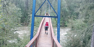
Bridge over Grass River
Connor crossing the bridge
From here the remaining 15 km was split between first being rained on for the first 10 km, walking through a narrow trail with soaked underbrush for about 3 km, and then happily drying out as we reached open hiking in the last 2 km. The actual trail was fairly nice, if a bit narrow and over grown in places, but it was easy to follow and looking out over the river all day was quite pleasant. There were also some really interesting mushrooms on the path.
Red mushroom cup
Some Gnochi shaped mushrooms, per Roslyn
At around the 13 km mark, we spilled out of the trees onto a rock outcrop over looking the start of the rapids before Kwasitchewan falls. This out cropping is also the emergency landing point for helicopters in the area, so don't camp on it.
Start of the rapids
River opens up again
After taking about 40 minutes to dry out some we continued onward. Upon reaching the first campsite at kilometer 14 we looked around it and found a privy. The first camping area was quite nice and open with decent water access, but we decided to try and get closer to the falls. This camping area could probably hold about 5-6 tents, and had no fire pit, bear box or picnic tables.
Campsite number 2 at 14.6 km was tight, with less easy access to water and no privy, picnic table or bear box. You could probably have fit 2-3 tents in but we decided it wan't worth it and we would check out the next site.
Campsite number 3 is right at the falls, and could probably fit 6-8 tents in the general area if you picked through all the downed trees. There is a privy at this site, but no picnic tables and no bear box.
After putting our packs down, we went over to look at the fall.
Top of the falls
We didn't manage to get many good pictures but we have some great video that will go up on our channel (once we get it setup of course). After looking at the falls for about 10 minutes I noticed that a giant black cloud was almost on top of us and we rushed to put up our tents. As the rain started to fall I finished up my tent, and Tyler was about 95% done his, but he did get a bit of rain inside. One thing to note about this site is that the soil is only about a half inch deep so we had to use rocks to hole the tents up instead of pegs. The rest of the night was spent alternating between hiding in the tent from the rain, eating supper, and looking at the water fall and the lake. We discovered that the waterfall has a rainbow in it as the sunsets!
In Roslyn's words:
This trip was our first real encounter with rain while hiking, and we did not handle it as well as we would have liked. I for one didn’t think I would need rain pants so I just wore gaiters and a rain jacket. Well, as soon as I was the one leading the pack and running into all the wet tree leaves, my pants became a waterfall right into my boots. Yup, sloshy boots for days (literally). It also was quite the drain on our attitude after 6 hours of being wet, but just like light at the end of a tunnel the sun came out just as we were reaching the river fork indicating we were near(ish) our camping spot. The actual trail on the way there was quite nice. Lots of roots, typical of a forest hike, and tons of super colourful mushrooms.
This trail goes past some rapids on the way to the falls (clockwise loop) and I strongly recommend you take the time to enjoy the rapids. They are massive! It really makes you wonder what kind of rock formation lays under the water.
Before this trip, the largest waterfall I had ever seen was Rainbow Falls in Whiteshell, and I knew I was going to be awed by the Kwasitchewan Falls, but man was I awed. I have never before seen something so powerful and authoritative. Also the daily rainbow when the sun shines at about 4:00 is quite spectacular. It actually lines up perfectly with a little island down the river a ways. At the end of the day, falling asleep with the eerily calming roar of Manitoba’s largest waterfall tens of meters away, is quite something.


No comments:
Post a Comment